
Having started a war in Ukraine, Russia has laid its cards on the table. One of the cards was the rocket terror of the civilian population, which ended up as strikes on critical infrastructure. This has deprived many of the country’s residents of basic domestic needs for heat, light, and water.
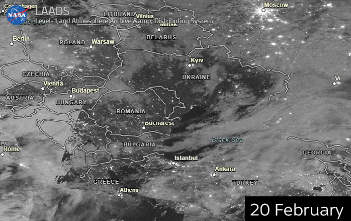
Moscow’s missiles have caused nations that have sided with Ukraine to start thinking about creating a powerful, multi-layered space-based missile defense architecture using Earth Observation (EO) satellite mechanisms. Early-warning missile threat satellites are the first part of this large effort to detect missile launches and create the conditions for further interceptions.
Thermal Spectrum Monitoring: The Launch of the MIDAS Program
The first missile early warning systems appeared in the United States at the peak of the Cold War. From 1960 to 1966, America launched 9 of 12 planned MIDAS (Missile Defense Alarm System) satellites into geosynchronous orbit.
The main task of the warning satellites was to track the waves in the infrared (IR) spectrum characteristic of the thermal radiation of the rocket engine at launch (>1000°C). The thermal track left by the missile, combined with information about its launch location, made it possible to calculate the missile’s trajectory, allowing the US missile defense forces to prepare for reflecting the threat.
Since the thermal radiation emitted by the missile was visible in the infrared range, the main element in the design of MIDAS satellites was the infrared sensor. The data captured by the sensor was processed by the satellite’s onboard computer. An essential function of the computer was its ability to analyze the information received and distinguish false alarms, such as sun glare reflected from the Earth’s surface or clouds.
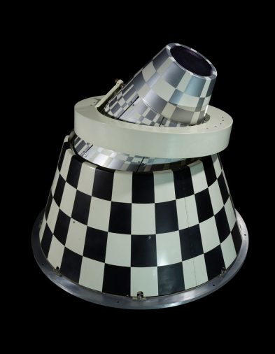
Source: Smithsonian National Air and Space Museum
MIDAS satellites were placed in Geosynchronous Earth Orbit (GEO). The launches could only be tracked successfully in the early stages of a rocket’s flight when its thrusters were active. On average, the Americans had only 3 minutes to see the first flash of a possible missile threat. After that, the rocket’s main stage engines would shut down, and the rocket would go into a low-altitude flight, making IR satellites useless for further tracking.
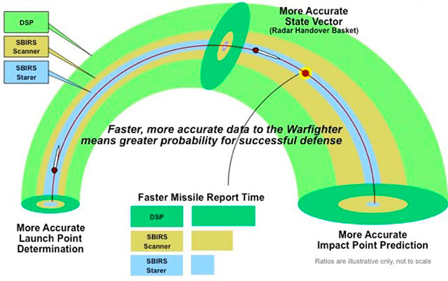
IR monitoring was somehow more reliable than radar detection, which provided threat information in the later stages of the missile’s flight when it was less than 20 minutes from approaching the target. The methodology of satellite infrared monitoring also provided visual data about the location and direction of the launch (although for the first spacecraft, it was of low quality). Despite a number of qualitatively new solutions, the MIDAS program was never adopted. Still, it paved the way for the development of future satellite-based early-warning systems for missile threats. These improvements resulted in the Defense Support Program (DSP) and the SBIRS that followed.
Sensors, Optics, and Laser Communications: DPR and SBIRS
The Defense Support Program (DSP) advanced infrared early-warning satellites that emerged in the 1970s were the ideological successors of the MIDAS satellites. They would serve the US for 37 years before being replaced in the early 2000s by new generations of SBIRS (Space-Based Infrared System) warning satellites.

The DSP system played a significant role during American military campaigns. For example, during Operation Desert Storm, the system tracked Iraqi Scud missiles fired into the territory of Israel and Saudi Arabia. As a result, hundreds, if not thousands, of civilians were saved, along with civilian and critical infrastructure, which had been the main target of the Iraqi missiles.
The DSP satellites’ image clarity was achieved with the help of a powerful wide-angle Schmidt telescope, which provided the orbiting images with high resolution. Between 1970 and 2007, the US launched 23 DSP satellites built by Northrop Grumman Aerospace Systems into geosynchronous orbit. The first DSP satellites were relatively lightweight (900 kg) and could remain in orbit only for 1.25 years. Later versions of DSP IR satellites would have a longer operational lifetime of up to 10 years. They would also be much heavier (2,380 kg vs. 900 kg) and more powerful (1,275 W instead of 400 W on the earlier models). Much of the increase in power was due to the increased number of infrared tracking detectors on the satellites.
Infrared orbital monitoring systems technology has not stood still, and since 2007, the DSP system satellites have been replaced with more powerful and reliable SBIRS spacecraft.
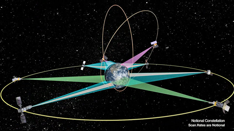
Source: Lockheed Martin
Part of the SBIRS ABM constellation satellites was already deployed in HEO (High Elliptical Orbit), which allowed expanding the coverage area of the monitoring satellites, especially in the area of the Earth’s poles. SBIRS also took the first steps towards the deployment of the constellation of satellites in LEO (Low Earth Orbit). The satellites of the SBIRS Low constellation were equipped with two types of sensors: an infrared scanning sensor (for the initial fixing of the launch) and an infrared tracking sensor (to track the further trajectory of the rocket flight). Further, it will become clear that this is the future of space-based missile defense, but in the early 2000s, it was not obvious, and it was decided to abandon the SBIRS Low program in its original form. Anyway, SBIRS Low developments have not been forgotten, and many of them have been embodied in the Space Tracking and Surveillance System (STSS).
As for the SBIRS satellites already deployed on GEOIRS, their main advantage was their multipurpose capability. Thanks to the introduction of highly sensitive optical sensors, SBIRS satellites could carry out not only infrared monitoring of missile launches but also successfully conduct point-directed reconnaissance activities.
New modifications to the infrared sensors made it possible to use the satellites to monitor launches of both strategic intercontinental missiles (which the DSP was also able to do) and short- and medium-range cruise missiles used locally. Henceforth, even a faint missile trace coming from the enemy’s tactical missiles was visible to the new sensors of the SBIRS constellation. Through high-speed satellite communication channels, this information was fed to ground data centers, where it was analyzed for subsequent decision-making on the interception.
SBIRS has become an excellent and versatile orbital dome against ballistic missile threats, but recent times have been marked by the development of more advanced types of cruise missiles. New hypersonic missiles capable of maneuvering and changing their flight trajectory will be a real challenge for space defense specialists. They will force a rethinking of all missile launch warning system technologies.
Betting on low orbit: tracking and hypersonic intercepts
MIDAS satellites, as well as DSP and SBIRS, were launched into a high geosynchronous orbit (GEO), allowing a single satellite to cover 50% of the Earth’s surface overnight. This tech solution had its adverse impact: rocket-tracking satellites were very bulky and expensive.
These satellites were designed to track intercontinental ballistic missiles, which, while traveling at tremendous speeds, lack the ability to change their trajectory, giving missile defense forces more time to prepare for interception. The new hypersonic missiles were a game changer. Their speed was still at least five times that of hypersonic (6,100 km/h), but now the missiles have the ability to maneuver, changing not only their direction but also their flight altitude.
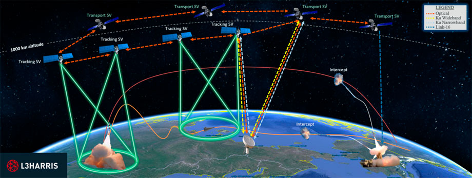
Source: L3Harris
Developers of satellite warning systems were faced with a challenging task for which no perfect solution has been found up-to-date. A possible solution to the new types of missile threats could be the creation of systems based on an integrated usage of early warning satellites on missile launches together with space-based missile interceptor systems (SBI from space-based missile interceptor).
The orbital ceiling to which such systems should be launched for their effective operation has also been rethought. Instead of GEO orbit, such constellations today are more often offered to be placed on LEO. From there, it is possible to track changes in the hypersonic missile flight trajectory more quickly and accurately.
New satellites equipped with HBTSS (Hypersonic and Ballistic Space Sensor) sensors are about to be used for tracking new types of hypersonic rockets, the first launch of which is planned for 2023. These satellites will probably communicate with the SBIRS system, functionally extending its architecture.
After detecting launches by IR satellites and transferring corresponding information via laser communication channels, anti-missile satellite systems of SBI – satellites equipped with anti-missile weapons – can be used to destroy a missile. With proper knowledge of the launch location as well as preliminary tracking of the missile’s trajectory, an SBI satellite can come close to it for further interception.
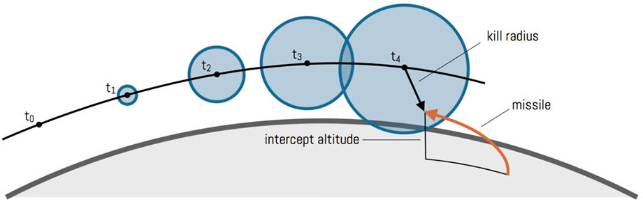
Source: American Physical Society’s 2004 “Study Group on Boost-Phase Intercept Systems for National Missile Defense.”
In the article titled What Can 24 Satellites Do for U.S. Missile Defense? published in October 2018, the author examined a number of nuances and controversies about SBI systems. Unsafe at this point appears to be the prospect of placing so many munitions in orbit that, if detonated, could cause a veritable orbital pollution disaster, endangering all telecommunications and science satellites on LEO. Part of this problem could be solved by creating new intercept systems that use laser weapons rather than conventional ones. The laser beam could be aimed at the optical sensors responsible for the missile’s orientation. According to information published in July of this year in The Space Review, the Russians have already started to develop ground-based laser installations capable of interfering with optical sensors on tracking satellites, so work in this direction is becoming more and more relevant.
Another weakness of such a constellation of space-based intercept satellites is their need to be in orbit en masse. Thousands of interceptor satellites may be needed to create a reliable coverage area capable of guaranteeing protection against hypersonic missiles. However, there are also successful examples here, including SpaceX with its Starlink satellite constellation. Over the years, the company has proven that even 3,000 satellites of a single system in orbit are not the upper limit. Ultimately, the question is how much defense agencies are willing to spend to build this type of system.
Obviously, the new war unleashed by Russia is forcing congresspeople to part with defense money much more easily. In July 2022, the Pentagon announced it intends to spend $1.3 billion to put 28 new missile-tracking satellites into orbit by 2025. Half of those vehicles will be developed by the efforts of Northrop Grumman Strategic Space Systems, and the other 14 by Florida-based L3Harris Technologies, Inc.
The future of anti-missile EO systems
It is clear today that the main focus in developing new generations of satellite-based EO systems is the implementation of a comprehensive multifunctional architecture. Satellites in different orbits will be able to provide a more stable presence and guarantee reliable coverage while minimizing the time required to track a launch.
Image: CSIS Missile Defense Project
The principles of laser inter-satellite communication implemented in such systems will noticeably increase the speed of spacecraft communication with each other and the data reception and processing stations located in the control centers on the ground.
Despite the trend of a gradual transition to LEO orbit, the developers of new systems do not give up GEO. Thus, the future successor of the SBIRS system will be OPIR (Overhead Persistent Infrared Block), which is being developed at the Space and Missile Systems Center (SMC or Space and Missile Systems Center). The new generation of OPIR systems will provide the US Air Force and Missile Defense with up-to-date information about missile overflight zones in the shortest possible time due to the use of the new satellite bus LM 2100, produced by Lockheed Martin. A key feature of the next-generation missile approach warning systems will be continuous infrared monitoring of the planet, enabling a 24/7 response to missile threats. By 2025, the first block of OPIR system satellites is expected to appear in orbit: three of them will be placed in GEO and two in HEO orbits.
The Space Development Agency (SDA) is also trying to strengthen the orbital anti-missile dome. The agency’s specialists have come up with an initiative to lease commercial stations to communicate with satellites on LEO. This will save millions of dollars allocated for constructing similar objects from scratch. Amazon is among the main lessors of such ground stations as it once built them for the needs of its Amazon Web Service.
The war in Ukraine demonstrated that in modern wars, the front line runs through the entire country since all enterprises, infrastructure, and the civilian population are exposed to the missile threat, regardless of their distance from the actual war zone. The safety and normal existence of millions of Ukrainians in the near future will depend on the timely development and implementation of new types of orbital early warning systems on missile threats.