Earth Observation Satellites, EO, have long patronized us from orbit. They monitor climate change dynamics and the pollution of the oceans by plastics. These satellites also assist with locating and combating the effects of human-made and natural disasters.
The newly aggravated problem of food scarcity made us take a new look at another significant role of EO-satellites – supporting the agro-industrial sector. Today, satellite monitoring technologies help control the level of crop yield, carry out planned irrigation of crops, and timely notice the danger of drought and pests, thus contributing to the preservation of crops.
EO satellites: from origins to the present days
The first satellite launched to study the Earth was a joint project between NASA and the US Department of Agriculture. The project was called TIROS-1, a meteorological satellite launched on April 1, 1960, and was primarily intended to make meteorological observations from orbit. Another purpose of TIROS-1, more fundamental, was NASA’s desire to demonstrate the possibility of targeting such spacecraft in orbit to monitor our planet.
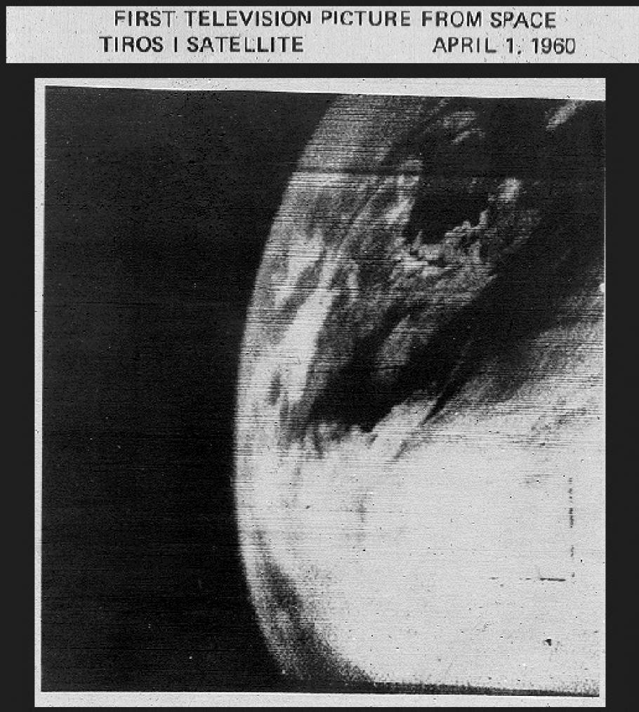
TIROS-1 was the first demonstration of what would later be called precision agriculture. This method makes it possible to determine terrain conditions, assess soil fertility, and monitor the weather. The new range of capabilities indirectly indicated that such satellites could help a lot in the agricultural field in the future. They will be especially useful where a large area or inaccessibility of the investigated lands does not allow a competent assessment of their main indicators from the ground.
Today satellite monitoring companies are ready to launch whole constellations of EO satellites capable of monitoring the overall condition of fields and forest areas with the possibility of updating the information every 24 hours. Small in size, these satellites can place sensors and optical cameras on their satellite buses to provide the most complete picture of the condition of crop fields worldwide.
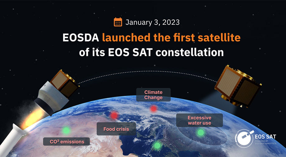
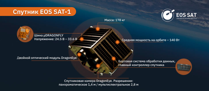
EOS Data Analytics, which plans to launch its constellation of 7 EOS SAT optical satellites into low-Earth orbit by 2025, seems to have achieved a perfect ratio in terms of lightness and multi-tasking of its monitoring satellites. The small EOS SAT-1, which the company plans to launch in early 2023, weighs as little as 178 kg and carries 2 DragonEye optical sensors capable of surveying in eleven spectral bands (the next constellation satellites will increase that figure to 13).
EOSDA estimates that each satellite from the future SAT constellation will be able to cover up to one million square kilometers, and the coverage of the entire satellite constellation after its launch will range from 8.6 to 9.4 million square kilometers (with the possibility of expanding the coverage to twelve million square kilometers).
Only 62 years after the launch of TIROS-1, humanity came close to permanent monitoring of 100% of the cultivated lands of the twenty most developed agrarian countries worldwide.
Spectral Sensing of Cropland
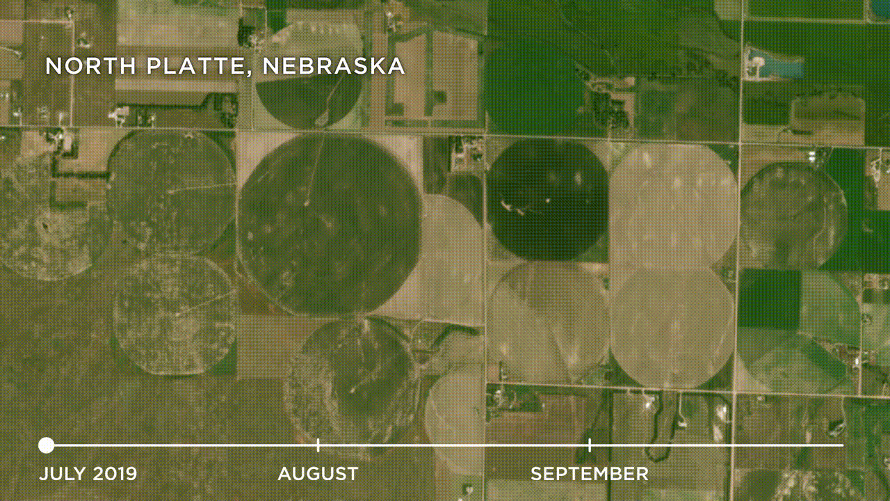
Regarding satellite monitoring, it should be noted that it’s not only about the usual optical observation of crop growth from space. The most valuable resource for precision farming is the methodology of remote satellite sensing of the earth’s surface using different types of sensors. This type of EO provides images of the earth’s surface in various electromagnetic spectrums. Such spectra are not susceptible to the human eye or an ordinary optical camera, but they conceal most of the valuable data related to the vegetation process.
The most common criterion for assessing the level of greening from orbit is the Normalized Difference Vegetation Index (NDVI from Normalized Difference Vegetation Index). The index indicates the level of the greening of the scanned land, up to a determination of the overall health of green areas. Spectral analysis, on which the NDVI index is based, allows one to notice the minor nuances of the vegetation process related to the lack of moisture, the presence of diseases, and other negative factors affecting the level of greening.
The technology emerged in the ’80s and was based on the visual definition of photosynthesis, the process by which plants absorb visible light. When light actively absorbs during photosynthesis, plants reflect large amounts of near-infrared light (NIRB) into the environment. Knowledge of the different light reflections in the infrared was the basis for the creation of the NDVI index, which allowed us to identify the greenest areas of our planet using remote sensing methods.
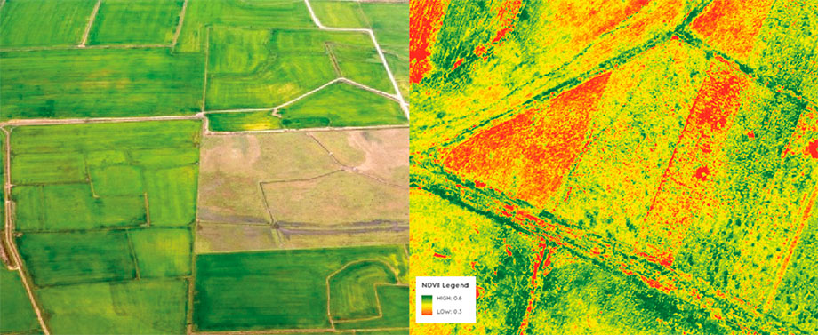
The NDVI index is on a scale of -1 to 1, with a maximum value of one being the glow reflected from healthy, dense-growing plants. Values between 0 and -1 indicate serious problems typical for diseased or wilting crops. As a rule, these numerical values are expressed as certain colors on the spectral image: green indicates a satisfactory state of the plant’s health, while yellow and red indicate the presence of unhealthy or wilting leaves.
Mapping such information is used to create fertility maps. This allows satellite orbital monitoring companies to create registries of interactive NDVI maps, which can be particularly useful if a farmer needs to make the right choice when acquiring new plots of fertile soil or simply check the condition of their own crops without visiting the farm.
Note that NDVI is not a universal vegetation index useful at all stages of the farming process. Today, many other hyperspectral data and indices help analyze a range of data related to the vegetative cycle based on various parameters. Hyperspectral narrowband data can provide information regarding soil type and moisture saturation, estimate leaf chlorophyll levels and create an index of leaf area, identify crops by their spectral footprint, and timely signal pest and disease outbreaks.
By decomposing the satellite image into spectra, we get the most complete picture of the sensitive parameters, the work which directly affects the future harvest. However, to unlock the full potential of agricultural satellite monitoring, it’s necessary not only to observe but also to perform a competitive analysis of the received data. Today such analysis is increasingly conducted by computer systems using artificial intelligence (AI) algorithms.
Intelligent forecasting at all stages of farming processes
Most data manipulation, analysis, and creation of yield forecasting graphs are done on the ground using machine learning (ML) algorithms. When predicting yields, the neural network uses a comprehensive approach, including the operation of both information received from satellites and data on soil conditions obtained from sensors installed directly on the farm.
Today, AI complements the overall picture obtained by satellite monitoring in areas such as:
- Yield forecasting
- Forecasting of diseases and presence of pests
- Forecasting water irrigation requirements for arable land
- Detecting soil areas with high-yield potential
- Predicting trends since the last image was taken
- Providing logistics routes for faster harvesting
- Forecasting and profit estimation
By creating computer models, satellite companies are able to calculate the bio-productivity levels of various crops. Estimating the level of bio-productivity helps to understand which of the crops grown on the farm has the greatest biomass of reproductive organs. In other words, which one is more productive. The information can be used to plan future planting campaigns focusing on the most profitable crops.
A similar task was successfully implemented by EOS Data Analytics in 2021, assessing the level of bio-productivity of crops for the agroindustrial sector of Kazakhstan. A biophysical model was created to perform the task, which used data on dry matter productivity (DMP or Dry matter Productivity), open data from the satellite monitoring program Copernicus Global Land Service, and meteorological data received from NASA Power. After the model was calibrated, it was able to determine the most favorable sowing and harvesting dates for five major crops grown in Kazakhstan and forecast which of them will be the most productive this season.
Industrial agriculture is particularly benefiting from the introduction of ML technologies into analysis, as the method gives the farmer (or farm manager) a clear picture of the growth dynamics of both crops and the farm’s business ecosystem. This allows adjustments to be made in time to achieve higher yields and, as a result, increase income.
Data analysis from satellite monitoring helps farmers and companies offering insurance in the land market. The trend is particularly popular in the US and Australia, where insurance companies actively use satellite data to track growing drought trends. Satellite imagery is also actively used to assess damage to the farm in the event of natural disasters such as floods or tornadoes.
Automation and comprehensive approach
It is wrong to believe that satellite monitoring and image analysis alone can guarantee the success of an agricultural enterprise. Any technology is beneficial only if an appropriate infrastructure can adjust to the data obtained. In other words, satellite data indicating the need for variable irrigation of your crops will simply be useless if your farm does not have an automated variable rate spraying system.
The same goes for evaluating soil quality from sensors on the ground. Suppose satellite monitoring can show you problems in specific areas without a detailed chemical analysis of the soil on site. In that case, this information cannot provide a full understanding of the issue. That’s why actively developing technologies of agrarian EE more and more often indicates the necessity of timely modernization of farms.
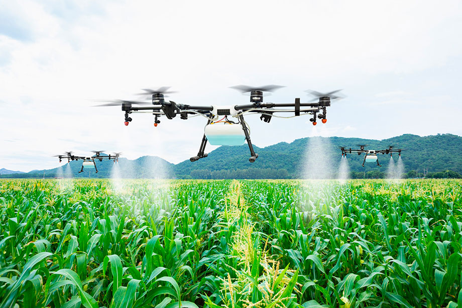
In some cases, the picture of satellite spectral data needs to be augmented by aerial reconnaissance, increasingly conducted with the help of drones. A great example of this is Precision Hawk, which leverages the resources of drones for a more detailed assessment of geospatial data from satellites. The company allows users to set their drone tasks using a mobile application. Some modern farms are not only using drones to conduct follow-up surveys but also connecting them directly to cultivating crops.
Source: Suwin/Shutterstock
Ultimately, the question of success with satellite monitoring data rests on the level of digitalization and farm automation. Implementing such technology from scratch is always time-consuming, requiring not only finances but also qualified staff capable of working with the information obtained.
Preventive measures: EO’s contribution to environmental preservation
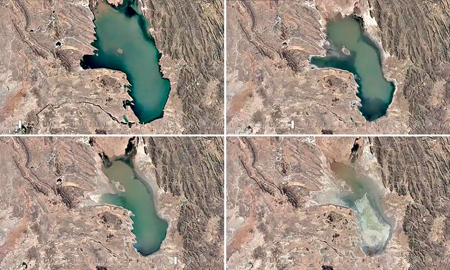
In addition to external political factors, the underlying root cause of the current food crisis remains in the continued regression of the world’s ecological situation. Increased CO2 emissions are predictably leading to higher average temperatures on the planet. This leads to higher levels of drought and an expansion of the areas in which it occurs. Once fertile lands are turning into a lifeless savannah.
In part, EO offers its own solution to this problem through smart resource allocation, helping to avoid overconsumption. In the context of large-scale farming, illiterate use of resources damages not only the farmer’s pocketbook but also has a bad effect on the quality of the soil. Unnormalized use of fungicides and other poisons to solve the problem of pests negatively affects the condition of the soil, reducing its yields. That’s why soil protection and conservation agriculture today are unthinkable without an accurate assessment of the fertility level of crops from orbit. EO provides such a resource.
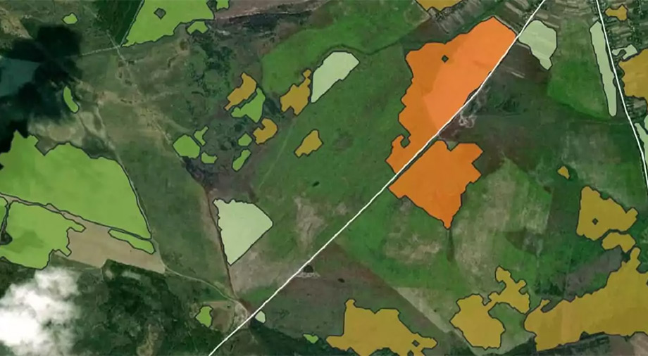
The EOS Crop Monitoring platform analyzes remotely sensed field data from the past few years and builds maps of crop productivity based on these images. The results of this analysis are visualized on display, indicating the least productive field areas. Productivity maps from EOS Crop Monitoring allow the farmer to assess the overall condition of the soil more accurately and work on soil health before the start of the sowing campaign.
Preserving the environment today can be an enjoyable as well as a lucrative endeavor. Some large companies are willing to pay for the amount of carbon your farm can absorb at carbon markets. The absorption rate is estimated based on satellite monitoring data. One ton of carbon dioxide absorbed can be converted into carbon credits (or allowances). Subsequently, farmers can sell them to large companies whose activities are related to the generation of carbon dioxide emissions. Today such companies as Perennial and Deveron are engaged in such a satellite assessment.
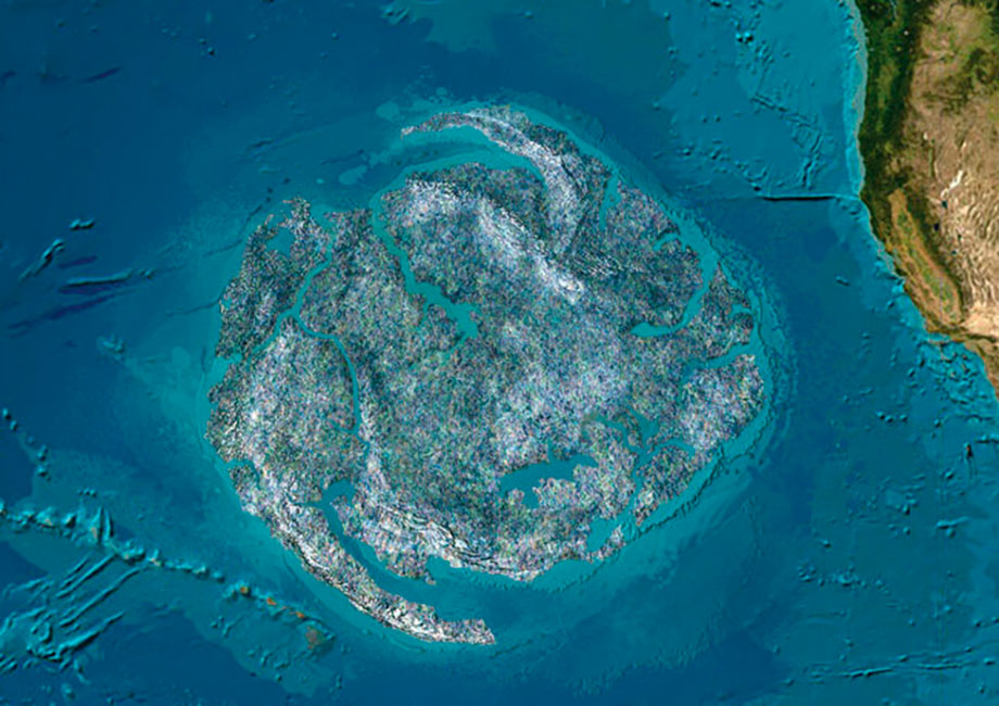
Satellites have also proven themselves in solving one of the most pressing environmental problems of the XXI century – pollution of the oceans with plastic. Ocean currents contribute to the spread of plastic in the water, sometimes creating real garbage islands, visible even from space.
Geoscientists and EO companies are actively working to develop new methodologies for satellite detection of plastic pollution hotspots in the oceans. One of the authors of the method for finding macroplastics in ocean waters is Dr. Lauren Biermann of the Plymouth Marine Laboratory. In the UK, Biermann developed the method based on an AI algorithm for analyzing satellite images from the Sentinel-2 satellite.
The methodology is based on the same near-infrared spectral analysis used in precision agriculture. However, while in the process of satellite field monitoring, specialists look for foci of chlorophyll presence, Dr. Biermann’s methodology works from the opposite – it looks for those areas near the ocean surface where photosynthesis is not observed. It’s the lack of luminosity in the NIRS range typical of algae that indicates the visible accumulation of material on the ocean surface is inorganic, being an accumulation of plastic.
Speaking about natural emergencies that have already occurred today, monitoring satellites make a huge contribution to the work of emergency services. They take part in localizing and assessing the extent of damage caused by natural and human-made disasters.
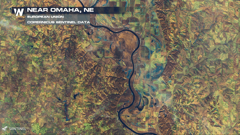
Images courtesy of the European Union Copernicus Sentinel Data
Today, satellite monitoring makes it possible to control all stages of the farming process, from the sowing campaign to the harvest. In many respects, the growth of successful integration of EO technology in farms plays into the hands of the increasing level of openness of satellite data and the ever-growing number of companies able to provide it. Developments in satellite monitoring technology are also contributing to the growing popularity of EO: new types of cameras are able to provide farmers with images of amazing clarity, blurring the line between satellite imagery and high-resolution aerial photography.
It’s becoming increasingly clear that precision farming technology will lead to a qualitatively new, smarter, and more economical approach to farming, allowing you to grow better and more while avoiding overconsumption of resources. If you couldn’t imagine a farmer 100 years ago without a plow and 50 years ago without a combine, in the near future, it will be unimaginable without communication with a satellite in orbit.