
Artificial Intelligence (AI) has already transformed life on Earth, and its arrival in orbit was only a matter of time. Today, this technology is used for a wide range of tasks—from detecting space debris to analyzing data collected in space. AI-powered applications are increasing the efficiency of space operations and are increasingly becoming standard tools for space engineers. According to David Salvagnini, NASA’s Director of AI, in the near future, “everyone will, in some way, have their workday augmented by some form of artificial intelligence.”
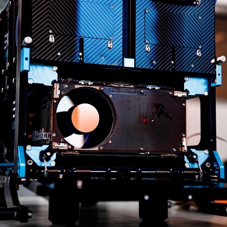
There are now satellites in orbit where AI was first used during development, then for operational control, and, finally, for sorting and analyzing data. In 2020, the European Space Agency (ESA) launched the nanosatellite Фsat-1 (Phisat) as part of the Federated Satellite System tandem mission (FSSCat). This was the first experiment to demonstrate the capabilities of AI in Earth observation: the satellite filtered out poor-quality images, helping reduce costs for transmitting and processing useless data. Four years later, its successor, Фsat-2, measuring just 22×10×33 cm, was launched into space. Six pre-installed applications onboard convert images into maps, detect anomalies in marine ecosystems and forest fires, as well as recognize, classify, and provide information about cloud distribution.
Source: nanosats.eu
Satellites like Фsat not only make it possible to assess captured images and exclude useless ones, but also to do so directly in space. Dense cloud cover devalues images, but since AI can recognize clouds in photos, only clear images are sent back to Earth, saving analysts time.
The number of practical examples of using artificial intelligence to support satellite operations or process their data is constantly growing. Here’s a closer look at some of the most interesting projects in this field.
AI in Earth monitoring and data analysis
Artificial intelligence reduces costs, extends mission durations, and collects higher-quality environmental data. Processed satellite images of Earth are used by private companies and governments for a wide range of tasks, from the obvious, like monitoring climate change, to calculating macroeconomic activity, which helps track migration flows.
Currently, over 300 satellites are photographing Earth from space, providing valuable information for geospatial analysis—a comprehensive study of changes on the planet’s surface. According to the ESA, all satellites combined can generate over 150 GB of data daily. These are massive amounts of information that need to be systematized and analyzed. Initially (in the early 1950s), this was done manually, and later with the help of technical tools. But in any case, it was a complex and labor-intensive task. Artificial intelligence changed everything. Now it handles the same work much faster, more accurately, and more efficiently, performing complex analyses almost in real time.

Source: NASA
High tech synergies in space
When we talk about artificial intelligence in space, we almost always mean that it works in tandem with machine learning (ML). This technology enables intelligent systems to learn, analyze information, recognize patterns, and adapt to changes. Machine learning processes data collected by satellites, identifies patterns, and predicts future events: for example, it can forecast weather anomalies, changes in vegetation, or glacier movement. It is machine learning that allows systems to better adapt to changing conditions, as in the example with cloud detection, identify subtle deviations from the norm before a satellite malfunctions (such as abnormal temperature graphs), and efficiently allocate resources: deciding which processes to carry out onboard and which to transmit to Earth for further analysis.
Some space-related information, both gathered and processed, is handled using deep learning (DL) and computer vision (CV) technologies. When combined with AI and machine learning, scientists can efficiently recognize patterns and develop algorithms to solve many practical tasks: analyzing large areas, classifying heterogeneous objects, monitoring land use, and conducting spectral analysis of environmental changes. All of this is applied in tasks related to wildlife conservation, urban planning, and disaster management.

Source: NASA
Artificial intelligence in agriculture and wildlife conservation
According to UN data, by 2084 the Earth’s population will exceed 10 billion people, with the bulk of the population growth occurring in the least developed countries of sub-Saharan Africa. This puts the continent at risk of an even more severe food crisis and drives the search for ways to increase the yield of its agricultural lands.
By using high-resolution multispectral satellite imagery along with AI and related technologies, humans are now able to forecast and improve crop yields through continuous monitoring of plant health, tree classification, and identification of waterlogged soil areas.
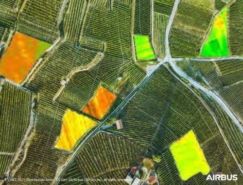
Source: AIRBUS Defence & Spac
In the wild, the capabilities of artificial intelligence and computer vision are useful for protecting and preserving national parks. Satellite data makes it possible to predict and prevent poaching and monitor the movements of specific animal species. Whereas such data used to be collected using camera traps, it is now gathered from space, without the need for exhausting manual analysis.
Satellite data analysis platforms
There is specialized software for post-processing, interpreting, and visualizing satellite data. Modern geospatial platforms provide users with access to pre-trained models, multispectral data, analytical tools, as well as computing power and large-scale storage. The intelligent systems described below allow for automatic object recognition, landscape classification, anomaly detection, and analysis of changes based on satellite data.
IBM PAIRS Geoscope
This platform collects and analyzes data from multiple sources, including satellite images, weather forecasts, and population data, and identifies patterns within minutes. PAIRS Geoscope has become a fundamental tool for vegetation management, and it is indispensable in the energy and utilities sectors. For example, it helps identify locations where trees and other vegetation pose a threat to power lines, thus preventing power outages. In agriculture, PAIRS Geoscope enables accurate crop yield predictions by processing satellite data on soil conditions, weather, and current land use.

Source: sciencephoto.com
EOS Data Analytics
This is another example of advanced tools that use high-resolution satellite imagery to obtain the most accurate and reliable data. EOS Data Analytics (EOSDA), founded by investor, entrepreneur, and philanthropist Max Polyakov, owns its own optical satellite, EOS SAT-1 (the first in the EOS SAT satellite constellation), and provides solutions for 22 industries, with a primary focus on agricultural and forestry issues. EOSDA combines data obtained from space with artificial intelligence technologies and its own patented algorithms to predict crop yields, monitor soil and vegetation changes, and detect potential threats such as droughts, pests, and crop diseases. Thanks to the combination of satellite monitoring and machine learning, the EOSDA platform helps farmers, agronomists, and businesses make more accurate and informed decisions, reducing costs and minimizing the negative impact on the environment.

Source: eos.com
Other projects
NASA also has powerful analytical platforms and specific software solutions for environmental monitoring using artificial intelligence: for example, SensorWeb for environmental monitoring. The intelligent system collects data from satellites and an extensive network of sensors to track the behavior of volcanoes, floods, and wildfires. For instance, when a volcano awakens in the southern Atlantic Ocean, the Terra and Aqua satellites with MODIS sensors take photographs of this area several times a day. They transmit images to the processing center, where the MODVOLC algorithms automatically identify areas of high temperature and send an alert. If the activity is confirmed, a request is sent to the EO-1 satellite, which uses onboard AI to adjust its scientific instruments and take higher-resolution images. After reanalysis, the images are sent to specialists to assess the situation and predict further developments.
Source: NASA
If SensorWeb is set up for general environmental monitoring, then Volcano SensorWeb, another NASA tool, is specifically adapted for analyzing volcanic activity. It also combines data from satellites and sensors, using artificial intelligence to monitor and predict eruptions based on data such as temperature, gas composition, crustal deformations, and other anomalies that indicate impending disasters.
Since March 2024, the Environmental Defense Fund’s satellite (EDF) has been helping fight global warming from Earth’s orbit, with methane gas being a significant contributor (scientists say it accounts for 30%). MethaneSAT maps, measures, and tracks the spread of methane across a large area with high precision, using cloud infrastructure and AI algorithms to analyze the images.
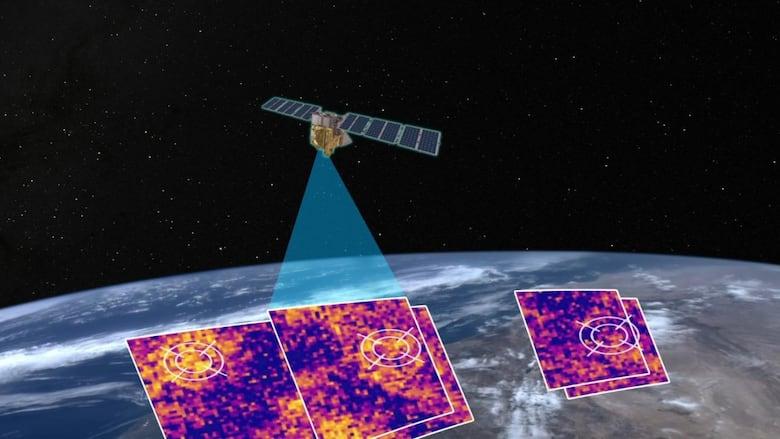
Source: MethaneSAT
Satellite data mining provides accurate information for other applications, including military ones. In March 2025, Ukraine gained access to a data processing platform to study French satellite images. The methods for analyzing satellite images are not disclosed for commercial reasons, but it is known that they involve the use of deep learning technology to detect and recognize military targets.
The use of artificial intelligence to assist satellites in tracking illegal fishing and pirate vessels from space looks promising. These vessels often disable their automatic identification system to avoid detection. Considering that half of the world’s ships carry cargo, and pirates attack over a hundred such ships every year, artificial intelligence is becoming a powerful weapon in the fight against this phenomenon. To address this, Mitsubishi Heavy Industries (MHI) has created a device similar to a typical Earth observation satellite, capable of processing visual data.
Artificial intelligence in the design and control of satellites
In satellite manufacturing, systems based on AI technology take over many routine tasks that are tedious and labor-intensive, but necessary, such as cleaning parts, checking assembly quality, and identifying microcracks and other defects that affect the satellite’s performance. Artificial intelligence also optimizes design by simulating various scenarios and helping engineers find the best solutions to complex problems. For example, machine learning algorithms analyze data from previous missions and suggest more efficient satellite configurations.
The startup Proteus Space used the Mercury intelligent system to determine the necessary components for ensuring mission accuracy during the development of the ESPA (Evolved Expendable Launch Vehicle Secondary Payload Adapter) satellite. Mercury is capable of evaluating more than 2,000 possible satellite configurations in approximately 10 minutes and, if necessary, adjusting its design in case of changes to its payload requirements.

Source: Proteus Space
Artificial intelligence increases the autonomy of satellites, reduces the risks of collisions, and ensures more accurate and safer execution of space operations. Researchers at the Massachusetts Institute of Technology (MIT) are using this technology for satellite traffic management and ensuring the sustainability of space operations.
Why is this important? The growing number of satellites in orbit automatically increases the risk of collisions. The situation is further complicated by the lack of centralized management, which jeopardizes the safety of the entire orbit.
So what did MIT do? They developed a model that combines reinforcement learning, game theory, and optimal control, which allows for effective management of overcrowded satellite orbits and reduces the risks of collisions. Essentially, satellites gain the ability to maneuver autonomously based on the current situation, without relying on instructions from operators on Earth. A similar system has already been implemented by SpaceX to minimize collisions with other objects in orbit.

Source: wikipedia.org
Artificial intelligence not only allows individual satellites to move autonomously and safely, but also to manage entire satellite constellations. This has become possible due to automation in decision-making, where high-tech approaches replace manual processes for planning, management, data collection, and resource allocation. Specially trained algorithms analyze mission objectives, weather conditions, and other important parameters in real-time to reduce the burden on operators on Earth. Additionally, intelligent systems dynamically adapt to changes, such as a significant increase in the risks of collision with space debris.
We have covered only one aspect of the interaction between artificial intelligence and space. In future articles, we will continue our exploration of this interesting topic and examine other points where space and AI technology intersect.


