Satellite images play a major role in Earth awareness and observation. Even simple two-dimensional images can provide a large amount of information about the object under study, especially when additional spectral filters are used in the final processing of the optical image.
But as time goes on, technology is constantly improving. The building of satellite constellations and leaps in the development of automated systems based on machine learning have strengthened the potential of remote Earth monitoring, which is based mainly on flat photographs of our planet’s surface and subsequent processing.
Today, we will discuss how close we are to three-dimensional satellite visualization of the Earth’s surface, and what advantages it could provide to humanity.
Types sensory observation
In fact, optical satellite imaging is not the only way to conduct remote sensing of the Earth. A wider set of data about the observed area of the Earth’s surface can be obtained by extending the range of electromagnetic scanning.
In fact, a photograph is just an imprint of the photon radiation of sunlight that falls on a camera’s optical sensor, capturing a mere instant. But visible light is only a fraction of the vast amount of wave energy that surrounds us in the universe. Detecting radiation in the radio, microwave, infrared, ultraviolet, laser, and other ranges. opens up wider possibilities for scanning.
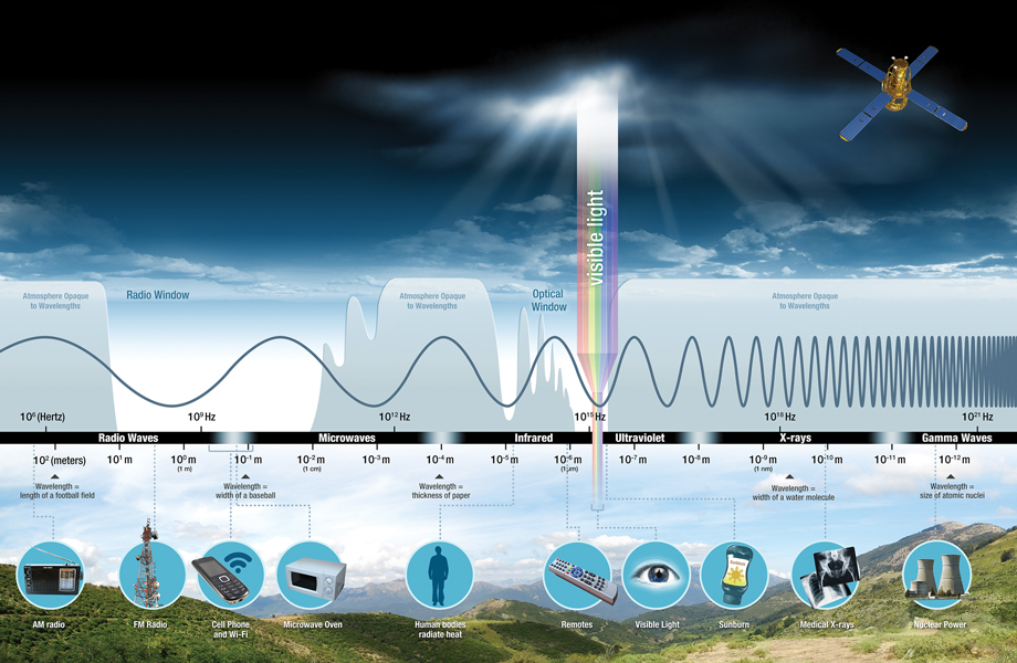
Credit: NASA Science
In fact, all these methods are fundamentally similar to each other, as they work on the principle of a rangefinder. First, a satellite sends an electromagnetic signal to the Earth’s surface. Upon contact with the surface, the signal is reflected and re-enters the satellite’s receiving sensor. By measuring the difference in time with which one or another reflected signal reaches the satellite, we can obtain an accurate topographical map of an area by assessing its elevation.
The main difference in these methodologies is the type of radiation used — some EM wavelengths, (like photon radiation of light) cannot pass through water vapor or clouds in the atmosphere, while others easily overcome the barrier to reflect off denser structures, like the Earth’s surface. It is microwave radiation that allows satellites with a synthesized aperture (SAR) to conduct remote monitoring of the Earth, even under cloudy conditions or in the absence of sunlight.
These spectral images are also important to global commerce, where accurate data on terrain elevation plays a major role. Companies involved in mineral, oil, and gas exploration gain significant benefit from the use of 3D terrain models. The technology is also highly relevant to the construction sector, where the exact topography of an area is important even during project planning.
Possibilities of spectral 3D visualization
Some of the newer satellite scanning techniques include tools that allow us to move away from the conventional 2D imaging offered by optical photography. One example is LiDAR (Light Detection and Ranging) optical technology, which, like SAR, provides a conceptually new vision of visualization of the scanning object.
This imagery is based on the very principle of operation of the LiDAR technology: first, the laser scanner sends short pulsed beams that bounce off the scanned surface and return to the receiving station. Similar to SAR, the distance to the object is determined by the time it takes for the emitted laser beam to return to the receiver. In just one cycle of emission and reception, a whole cloud of data points is recorded on the sensor.
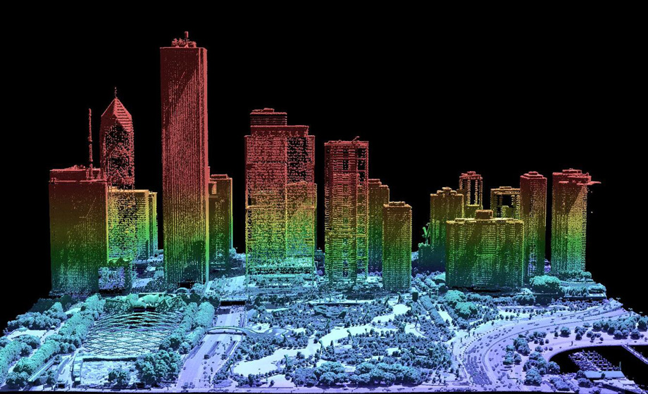
The final processing of this cluster of points using digital relief modeling (DEM) methods allows us to get a fairly clear picture of all the subtleties of the relief, and of much higher quality than that of the vast majority of optical cameras.
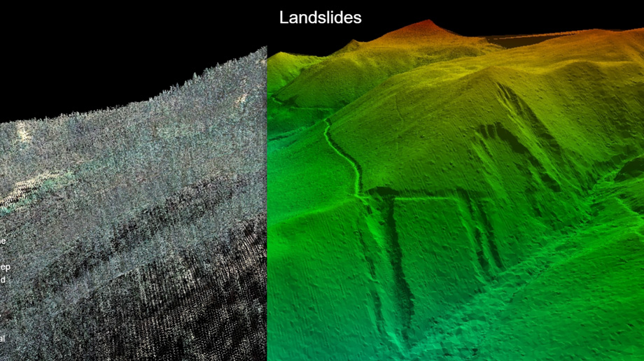
Credit: usgs.gov
LiDAR and various types of SAR radars have allowed us to see objects at a fundamentally different level of perception. This kind of “vision without vision” also provided the ability to improve the accuracy of measured data with the help of repeated flights of the scanner over the area of interest (scanning the terrain at different angles allows us to eliminate “blind spots” and to spread the use of image improvement methods using DEM and other models).
The uses of LiDAR systems have rapidly expanded, and today they can be found on airplanes, drones, high-altitude stratosphere balloons, and satellites. The use of lasers quickly spread beyond the boundaries of Earth research. The technology was applied in the FASOR (Frequency addition source of optical radiation) optical system — a directional space laser which the US Air Force Research Laboratory uses to conduct experiments to create artificial laser guide stars.
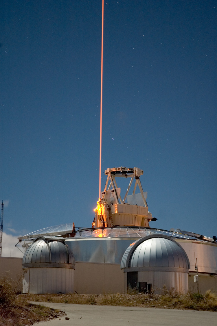
Credit: U.S. Air Force
The creation of an artificial “laser guide star” is achieved by pointing a laser (or group of lasers) into the atmosphere. The rays converge at one point in space and form an artificial glow. This artificial star in the night sky is used by adaptive optics systems to reduce the distortion effect from light and better focus on objects in deep space.
But let us return to the mapping possibilities that LiDARs and radars open. Satellite LiDAR and SAR systems are also used to map the landscape of moons, asteroids, and planets of our Solar System. There are even proposals to use telescopes for this innovative approach in creating three-dimensional topographical awareness for future visits to the Moon.
Based on the technology of the world’s first 4D LiDAR (3 spatial dimensions + time), the Aeries™ II from Aeva, NASA is developing a Kinematic Navigation and Cartography Knapsack (KNaCK) equipped with a LiDAR station. KNaCK is able to provide an astronaut with a complete real-time three-dimensional map of his environment by measuring the Doppler shift of the reflected laser signal.
This is achieved by Avea’s 4D LiDAR sending out a frequency modulated continuous wave (FMCW) laser capable of updating information about the environment with a negligible time delay. This will be very useful when using the station in extraterrestrial conditions where there is no GPS or GNSS coverage.
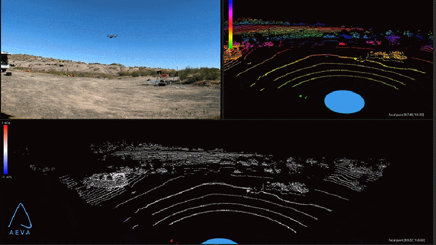
Credit: NASA
Thus, radars, LiDARs, and other types of sensors have proven themselves for primary measurement of the topology of surface heights. While operating in their areas of responsibility, these satellites gradually update altitude data, which are then reinforced with additional observations from Earth. This is how the main elevation databases of the Earth’s surface were created, many of which you can find today with open access.
But the real magic begins when building a three-dimensional model of an observed area, which combines high-level data about the surface and optical satellite photos with different resolutions.
Additional dimension for photo images
You are probably familiar with services like Google Earth, where the user is given access to millions of satellite and aerial photographs of the Earth which can be viewed in full 3D when zoomed. This is possible thanks to the use of complex digital relief models (DEM), whose algorithms create a complete three-dimensional landscape map based on satellite observation data.
When creating a digital model of terrain, a number of methods are used at once, some of which are based on the phenomenon of stereoscopy — the artificial deepening of a regular 2D image. Today’s AI-based systems are able to create a fully three-dimensional model based only on satellite images and current elevation data of an area that can be digitally modeled. It should be noted that previous generations of DEMs were also capable of this, but with a significant involvement of human resources in the modeling process and with significantly greater time costs.
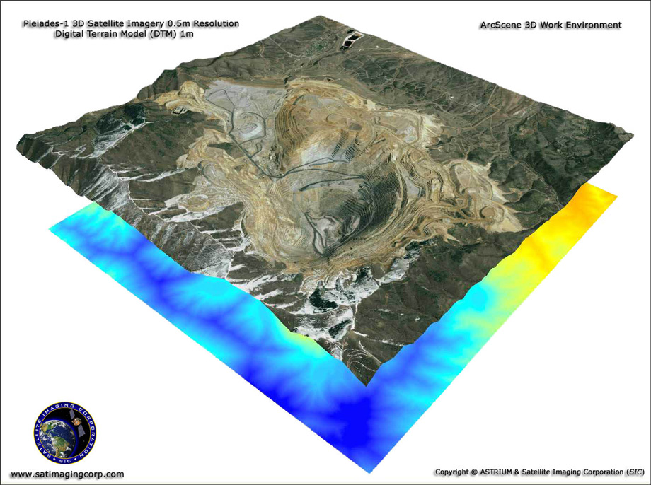
Credit: satimagingcorp.com
In addition to the growth of the capabilities of AI systems, another factor increasing the rate at which geospatial data is being updated is the use of target satellite constellations. Satellites working as part of a unified group are able to focus on a single area of interest and scan objects at different angles in relation to the Earth’s surface. This predictably provides more information regarding elevation levels and other topological features of the terrain. Satelltie constellations also greatly expand coverage area, allowing for relatively fast scan data updates. This has its benefits in cases of fast-moving natural or artificial disasters.
The creation of three-dimensional models of the landscape is increasingly involving methods of combined observation, in which the data of satellite scans of the Earth’s surface are expanded with the help of repeated scanning data from unmanned aerial vehicles (UAVs). This multidimensional architecture significantly increases the stability of the systems, offering an extraordinary level of awareness when repeatedly scanning individual areas with the help of drones.
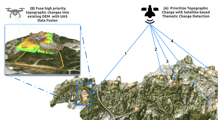
Credit: mdpi.com
As you can see, even the most accurate primary spectral analysis data require additional processing using digital modeling methods. Today, many of them already work with connections to multi-view stereo (MVS) neural networks, which increases the speed of 3D map construction. These networks are able to estimate height maps from satellite images, and then transfer them as a 3D point in a coordinate system to create a digital model of the surface. (DSM) or digital relief model (DEM).
One of the most interesting (in the context of our story) digital relief models is called the 3D Elevation Program (3DEP). It was developed in 2012 and is managed by the National Geospatial Program of the US Geological Survey (USGS). The 3DEP model is constantly updated and interacts with a number of topological databases, including data from the National Enhanced Terrain Assessment (NEEA), as well as the National Geospatial Program (USGS) Standards and Specifications.
Beginning in 2020, 3DEP was transferred to cloud storage format, known as the Cloud Optimized Geotiff (COG), which significantly reduced the level of computing loads and facilitated interaction with end users. 3DEP modeling is used only for the US.
Obtained using LiDAR
Credit: usgs.gov
The great potential of new three-dimensional awareness systems is also revealed when mapping the landscape on other planets, such as Mars, where interactive maps can be created using satellite image parameters. Even Global Navigation Satellite System (GNSS) signals can be used to create 3D maps by analyzing signal strength patterns and estimating building heights.
Satellite stereo imagery is particularly important for global markets where accurate elevation data is not available due to insufficient coverage by other global geospatial services. Many commercial end users will benefit from 3D digital terrain models, including maps for oil and gas exploration, best-fit areas for mining, design and construction, urban planning, environmental monitoring, agriculture, and forestry. Some services with 3D Earth mapping allow their users to study more specific things – for example the service Earth 3D Map contains the most detailed map of earthquakes.
Three-dimensional Earth mapping technologies are experiencing a new birth these days. New methods of constructing three-dimensional surface mapping models are being used everywhere, from the Earth to other planets. This technology remains especially valuable in the absence of GPS and GNSS coverage, where even portable ground sensors are capable of making a complete three-dimensional map of the surrounding environment.