The Human history of navigation dates back to when humans first populated the Earth, leaving the African savannah. Our ancestors used fixed geographic objects like rivers and mountain ranges as landmarks. They also, of course, used the stars in the sky, and it was our fascination with these that gave impetus to the start of the era of global satellite navigation. But there was a long way to go to reach that point.
We present here the first part of a brief history of navigation. In this article, we explain how humans developed the art of orienteering, from ancient times to the end of the 19th century.
Problems of ground orientation
Navigation is a set of knowledge and methods for determining the spatial position of objects relative to given landmarks. Navigation is also understood as deriving the shortest route from one coordinate point to another. This area of expertise is called routing.
To plot a route and navigate terrain, it is necessary to account for a number of variables, including time, the body’s position in space, its speed, and its vector. Obviously, ancient people faced a number of serious problems in determining this information, and most issues had to be resolved empirically.
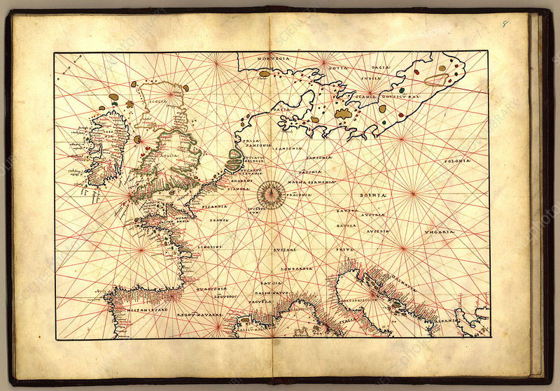
In addition, it was necessary to have knowledge about the landscape of the area being navigated. To solve this problem, since ancient times, people have used maps: visual displays of the terrain on a two-dimensional plane, like a clay or wooden tablet, leather scraps, and eventually parchment.
Ancient people also had no idea how to properly keep track of time, since there was no well-established understanding that time could be counted with short, equal intervals. Initially, they used sundials for this purpose. During the movement of the sun across the sky, the shadow from the sundial’s pointer moved in a circle, showing the approximate current time of day.
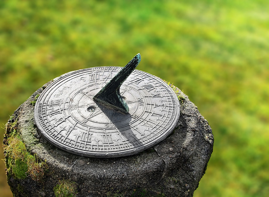
The sundial was replaced by the hourglass, and later by mechanical clocks, but both of these implements still carried a rather high margin of error.
The final (but no less difficult) problem was determining coordinates on the ground. On land, this could be managed somewhat using natural or man-made landmarks, but it was a far more serious challenge out at sea. To solve this problem, people used the stars to help them find their relative location and direction. Later, a coordinate grid system was developed which established location based on the intersection point of parallels and meridians (lines of latitude and longitude of the Earth) that were calculated in relation to the four cardinal directions.

Navigation by the stars: astrolabes and sextants
The first man-made system for maritime navigation was the use of a chain of lit fires located along coastlines. Bonfires were maintained at fairly high altitudes above sea level, so that they could be seen from the water. This is how the ancient Phoenicians, Greeks and Egyptians navigated at night four thousand years ago.
The location of celestial bodies also helped ancient seafarers to navigate. In the Northern Hemisphere, the main guiding point was the brightest point in the night sky – the North Star. In the daytime, ships were guided by the celestial position of the Moon and the Sun. The latter always rose on one side of the horizon, and set on the opposite side, denoting two different directions from each other: east and west.
In ancient Greece, navigators charted courses using an astrolabe – a rounded copper plate with a movable disk (tympanum) inscribed with a map of the constellations.
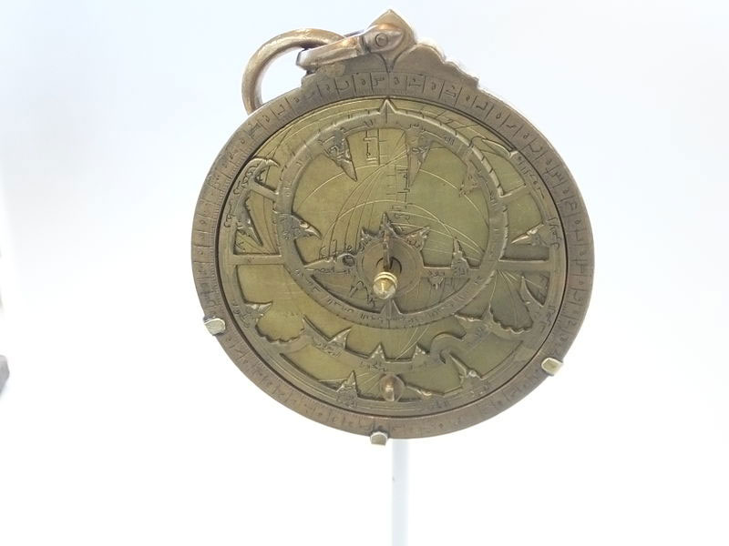
source: wikimedia.org
With the astrolabe suspended by a string and aligned with the line of the horizon, the ancient Greeks would compare their constellation map with the sky, and then move the disk in accordance with the movement of the stars in the sky. Thus the Greeks, and later the Arabs, were able to keep track of the length of day and night, as well as the cycle of seasons.
Sailors in the 17th century modified the ancient astrolabe, gaining the ability to navigate not only in time, but also in space. They used a device called a sextant, which is a goniometer that measures the angle of the Sun with respect to the horizon. With the sextant, navigators were able to determine their geographic latitude, knowing the angle of the sun in the sky relative to the current date.
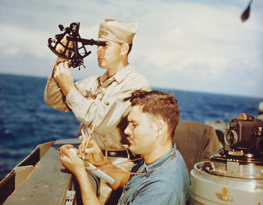
source: www.usni.org
Sextants were actively used by navigators during the 17th-19th centuries, however, for more accurate navigation, sailors needed an accurate accounting of the time in order to avoid measurement errors. In addition, the sky was not always clear.
The first magnetic compasses and mapping
In conditions of poor visibility, sailors resorted to another device called the compass, which enabled orientation using the Earth’s magnetic poles. In its most primitive form, a compass is a dish filled with oil or water, in the center of which is a magnetized needle. The needle is stuck into a piece of light wood or a straw so that it does not sink in the liquid. In the absence of strong pitching, the magnetized needle always points in one direction: north.
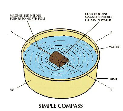
source: cdn.britannica.com
The design of the first Chinese compass from the middle of the 11th century is described in a similar way. In Europe, people also knew about magnetic orientation: medieval Scandinavian sailors had a similar primitive version of the compass, which was called the “Sun Stone” (Solar Stein). Thus, by the early Middle Ages, mankind had an idea of the four cardinal directions: north, south, west and east.
The real development of compass navigation took place in the 16th century – the era of great navigators and geographic discoveries. By this time, navies already felt an urgent need for mapping areas, in particular for creating depth maps. In addition, shipping maps of the past bore directions to all significant ports in the map’s region. This technique of leading lines is called the “compass rose.” It indicated the direction of motion vectors and was divided into eight key directions of light: 4 main (N, S, E, W) and 4 intermediate (NW, NE, SW, SE).
source: media.sciencephoto.com
Although ship compasses helped to determine the direction of a ship’s movement, it did not give any information regarding its position on the geographic grid of coordinates. To do this, it was necessary first to learn how to accurately calculate a ship’s degree of latitude and longitude in space.
Tracking time and calculating longitude
People have known since antiquity how to determine latitude using the angle of inclination of the North Star (or the Sun) with respect to the horizon. The situation was quite different with calculating longitude, which involved comparing differences in time. It was necessary to know the exact time of the initial location of the ship and the time of its current geographical position in space.
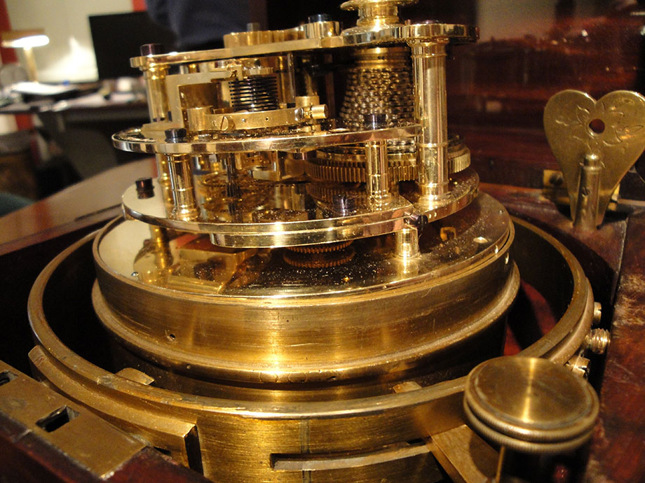
However, even the best mechanical clocks of the early 18th century were not able to run accurately and continuously for at least a full day. The average margin of error of the first mechanical watches was 10-15 minutes a day, which, during long voyages, could lead to catastrophic results. In just a day, the margin of error in calculating a vessel’s position could reach 240 kilometers (150 miles).
Then, in the 18th century, there was an invention which completely revolutionized maritime navigation: the marine chronometer. An analogue of the mechanical watch, it was invented in 1764 by the British watchmaker John Harrison. The Englishman’s innovative clock was able to compensate for the mechanical issue (which caused earlier clocks to lose time) by means of a special balancer. Thanks to this feature, the marine chronometer could bring down daily time loss to 5-15 seconds per day.
source: qph.cf2.quoracdn.net
In 1779, armed with Garrison’s marine chronometer, James Cook made his voyage around the world. Upon his return, the navigator discovered that his calculations of longitude using the chronometer were off by only 13 kilometers (7 miles).
Thus, by the end of the 19th century, humanity approached with a dramatically new level of understanding of navigational principles. However, the technologies of the past only helped people calculate routes manually, and did not allow for tracking changes in real time. To make this possible, there had to be a real revolution in the field of electrophysics. That revolution would be over the horizon in the 20th century.
To be continued