Spring 2025 saw strengthened cooperation between the EU and Ukraine in the space sector. On April 9, for example, an agreement was signed to involve Ukraine in a number of European space initiatives, including Copernicus, Space Weather Events (SWE), and Near-Earth Objects (NEO). Together, these programs cover a significant part of Europe’s overall space activities and focus on a wide range of tasks, from monitoring space weather to addressing planetary security challenges. In October 2025, it also became known that the European Commission had begun the process of integrating Ukraine into the European secure governmental satellite communications system, GOVSATCOM.
In many respects, this new chapter of Ukrainian-European cooperation in the space sector was a logical continuation of the EU–Ukraine Association Agreement signed in 2014. The ultimate goal is the full integration of the country into European systems for satellite early warning, communications, Earth observation, and space meteorology. But what exactly does Ukraine’s accession to the EU’s space initiatives mean, and how can Ukrainian specialists strengthen European space capabilities?
Europe’s eye in space: the strategic significance of the Copernicus program
The Copernicus program emerged as a long-term European Commission and European Space Agency (ESA) program in the early 2000s. At that time, the initiative was known as Global Monitoring for Environment and Security (GMES), and its main goal was to provide Europe with full and continuous access to satellite data for observing the Earth.
In 2008, the European Commission officially renamed the program to Copernicus in order to emphasize the distinctly European character of the initiative, referring to the scientific works of the Polish astronomer Nicolaus Copernicus. Building this sort of space infrastructure was part of Europe’s response to global challenges, from climate change and natural disasters to the need for efficient management of natural resources and ensuring the territorial security of EU member states.
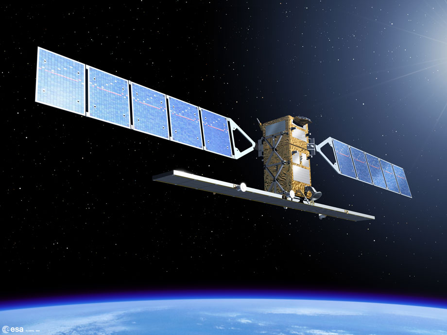
It may seem surprising now, but for more than 10 years, the Copernicus program did not have its own satellite assets and initially relied on the capabilities of ESA and EUMETSAT. As a result, at different times it used Earth-observation data from the Envisat, ERS-2, Meteosat, and MetOp satellites. In addition, a number of national and commercial European satellite missions contributed to the information-gathering process: the French Spot and Pleiades, the German radar satellites TerraSAR-X and TanDEM-X, and the American Landsat spacecraft. Copernicus gained its own operational capacity only in March 2014, with the launch of its first dedicated satellite, Sentinel-1A, which was designed specifically with the program’s goals in mind.
Source: esa.int
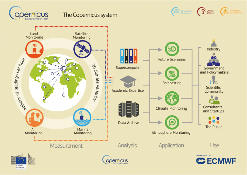
The Copernicus initiative operates on the basis of an exceptionally well-coordinated architecture consisting of just three main components.
The first component is the space segment, which forms the fleet of Sentinel monitoring satellites. Each spacecraft in this constellation carries specialized instruments for Earth observation and is responsible for collecting primary remote-sensing data, from monitoring glaciers and the atmosphere to land and oceans. The Sentinel constellation is managed directly by ESA, which is also responsible for the design, development, and launch of new generations of monitoring satellites.
The second component is the in-situ segment, meaning ground-based, airborne, and marine measurements that complement and verify satellite data. This includes meteorological stations, ocean buoys, and air-quality sensors. The ground network provides the accuracy and validation needed to turn raw satellite imagery into scientifically reliable, high-quality data products. Management of this segment is distributed across several national and European institutions.
Finally, the third component, and the most important for end users, is the service segment. This is the final stage that transforms vast volumes of monitoring data into user-friendly information products and services. The Copernicus service component offers six major thematic services: atmospheric monitoring, marine environment observation, land and climate-change monitoring, plus security and emergency-response services. The European Commission manages this segment together with the EU Agency for the Space Programme (EUSPA), which is responsible for user engagement and the development of the service market.
Source: researchgate.net
At the initial stage of deployment and development, every EU member state at the time joined the Copernicus program, as did Norway and Switzerland, as associated members participating in budget formation and governance. Their primary goal was to ensure that their citizens, government bodies, and research institutions had free and open access to satellite data, since such openness made it possible to make science-based decisions in all areas, from urban planning to environmental legislation. This level of openness remains a cornerstone of the Copernicus initiative.
The key advantage for countries participating in Copernicus has been a significant strengthening of their resilience and strategic autonomy in the field of space situational awareness. Although the program is officially positioned as entirely civilian, satellite monitoring data have also played a major role in security and defense. Today, these data support situational awareness for monitoring Europe’s borders; tracking major movements of troops or equipment; assessing the condition of critical infrastructure; providing general support for peacekeeping operations; and ensuring an adequate response to crises. This is exactly what happened in 2022, when, after Russia’s full-scale invasion of Ukraine, Copernicus became one of the important tools used by the European Union to provide Ukrainian forces with intelligence data, which were subsequently used to monitor military actions and assess the global consequences of the war.

Source: nature.com
Copernicus is employed in Ukraine primarily through the Emergency Management Service (CEMS), which was rapidly engaged for active mapping of territories affected by hostilities. In particular, CEMS assessments included determining the scale of destruction of civilian infrastructure and rapid analysis of damage to critical infrastructure. EUSPA, for its part, launched a special initiative in April 2022 called EUSpace4Ukraine. This program provides important data for monitoring cropland, forecasting yields, and tracking storage infrastructure, including the condition of grain elevators and other logistical facilities needed for grain exports.
As the full-scale war enters its fourth year, full-scale involvement in the Copernicus program is especially important for Ukraine because it ensures access to geospatial information, allowing the government and the military to strengthen their situational awareness.
However, participation in Copernicus does not only benefit Ukraine, since Ukraine also provides significant feedback that can contribute to the overall development of the European program broadly. In particular, Ukraine can substantially reinforce its in-situ (ground-based) component and has its own scientific potential in the fields of space research, electric satellite propulsion development, sensors, and satellite data processing systems.
Integrating Ukrainian data from meteorological stations or regional air-quality monitoring centers into the pan-European network promises to improve the accuracy and coverage of Copernicus services, especially along the EU’s eastern borders, which will be of strategic importance for overall security. In addition, Ukraine will likely take an active role in expanding the program through the initiative known as Copernicus Sentinel Expansion (CSE).
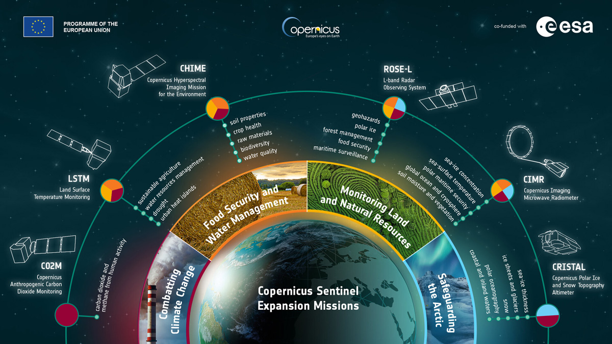
Copernicus expansion and new capabilities
The goal of the next stage of the Copernicus program is to expand the satellite fleet and deepen the capabilities of the existing Sentinel constellation. This includes increasing overall efforts to combat climate change, monitoring polar regions, and improving sustainable resource-management processes.
The Copernicus Sentinel Expansion program will consist of six new missions, each of which will be unique and designed to fill existing gaps in Earth observation. For example, the Copernicus Anthropogenic Carbon Dioxide Monitoring mission (CO2M) will, for the first time in European practice, provide measurements of anthropogenic carbon dioxide emissions at the level of individual countries and regions. This is expected to become critically important for assessing how countries are meeting their climate-protection commitments, especially those outlined under the Paris Climate Agreement.
Another mission, the Copernicus Imaging Microwave Radiometer (CIMR), will focus on the Arctic, gathering detailed data on sea-ice concentration, and on sea-surface temperature and salinity. This is essential for understanding the environmental dynamics of the planet’s most vulnerable region and for supporting maritime operations.
In addition, the Expansion includes missions aimed at more detailed observation of the Earth’s surface. For instance, the Copernicus Hyperspectral Imaging Mission for the Environment (CHIME) will produce high-resolution hyperspectral images to significantly improve agricultural monitoring, forest management, and mineral detection. The forthcoming Land Surface Temperature Monitoring mission (LSTM) will provide highly accurate monitoring of land-surface temperature, which is key for water-resource management and drought forecasting.
Overall, these six new missions, which also include CRISTAL (ice-sheet monitoring) and ROSE-L (an L-band radar for soil and biomass), will represent a major technological leap, expanding the EU’s Earth-observation capabilities to a new, more detailed level.
Source: esa.int
At the end of 2025, Copernicus Sentinel Expansion is in the stage of active development and early implementation. At present, ESA and the European satellite industry are working on creating the new satellites, which are now at various stages of production and integration. The first launches under the Copernicus expansion program are expected to begin after 2028. Before that, however, launches of replacement satellites in the existing Sentinel constellation are planned (specifically the Sentinel-2C/2D and Sentinel-3C/3D pairs).
As it integrates more fully into the Copernicus program, Ukraine can also contribute to its expansion, although it is unlikely that it will take direct part in building new satellites under CSE, since all the main contractors have already been selected. However, Ukraine is quite capable of helping with the development of new types of applications or ground-segment equipment for receiving satellite data.
Ukrainian companies will also have the opportunity to participate in new European tenders and projects aimed at calibrating and validating satellite data, or at developing software services and products based on hyperspectral data from CHIME or radar data from ROSE-L. The result may be the adaptation of satellite data for the needs of national security, postwar reconstruction, and agriculture. In any case, Ukraine has the necessary expertise to bring new services into practice.
This is evidenced, in particular, by the experience of EOS Data Analytics, a company with Ukrainian roots that specializes in processing satellite imagery. Other Ukrainian companies involved in the space market, such as the manufacturer of satellite electric propulsion systems Space Electric Thruster Systems (SETS), may also join the process of creating the new European satellites that will succeed the Copernicus program.
Participation in SWE, the most accurate space weather forecast
Another program Ukraine joined in 2025 is Space Weather Events (SWE). This is part of the Space Situational Awareness (SSA) program, designed for monitoring space weather. This ESA initiative began taking shape in the mid-2000s, when European countries realized the growing vulnerability of their terrestrial and space infrastructure to solar activity. The main goal was to build, within the EU, an independent system of space meteorology and forecasting that could reduce risks and ensure the resilience of critically important systems during emergencies caused by space weather.
It is important to understand that SWE does not deal with traditional, purely Earth-based natural disasters such as floods or earthquakes, but is focused exclusively on monitoring the Sun as the primary source of space weather phenomena in our solar system. Space weather refers to the set of conditions in space (from the Sun to the Earth’s atmosphere) capable of affecting technological systems. As such, SWE will monitor solar flares, coronal mass ejections, and high-speed solar-wind streams. These phenomena trigger powerful geomagnetic storms that can damage near-Earth satellites and, as a result, disrupt the functioning of systems on Earth.
Source: esa.int
Although modern satellites are equipped with enhanced shielded protection (so-called radiation-hardened electronics) and no cases of satellite electronics failures caused specifically by space weather have been recorded over the past decades, geomagnetic storms can nevertheless alter the environment in which they operate. During geomagnetic storms, high-energy solar radiation is transferred to the upper layers of the atmosphere, causing heating and expansion of these layers. As a result, spacecraft in low Earth orbit (LEO) experience a significant increase in atmospheric drag, which accelerates orbital decay and requires more frequent maneuvers to correct their orbit. This, in turn, rapidly depletes their fuel reserves and shortens their operational lifespan.
The most notable recent incident involved the loss of 38 newly deployed Starlink satellites on February 3, 2022. The launch of 49 satellites into orbit coincided with the beginning of a moderate G1-class geomagnetic storm (which later intensified to G2). The storm caused significant heating and expansion of the upper atmosphere. Consequently, the Starlink satellites, which reached an extremely low initial orbit (around 210 km), encountered a sharp increase in atmospheric drag, resulting in the loss of nearly 80% of the spacecraft launched.
The SWE system operates through a network of ground-based telescopes and sensors, as well as satellite instruments that continuously monitor the Sun and measure solar wind parameters near Earth. The collected data are processed and transformed into predictive models and alerts, which are vital for operators of critical infrastructure. SWE provides information to adjust satellite orbits to minimize the impact of increased atmospheric drag caused by geomagnetic storms.
Incidentally, SWE data also directly affect the safety and economy of sectors beyond space operations. For example, airlines use these forecasts to plan routes, particularly at high latitudes, to avoid communication problems and excessive radiation risks to passengers and crew. Power grid operators can also take preventive measures to protect transformers from geomagnetically induced currents (GICs), which can cause overloads and large-scale power outages. One of the most striking historical examples of the destructive impact of such currents was the Carrington Event of 1859, when an extremely powerful solar storm triggered a prolonged failure of terrestrial telegraph networks.
Source: swe.ssa.esa.int
Today, SWE serves as one of the tools for protecting our technological civilization, preventing catastrophic failures of life-support systems. Timely warnings about strong geomagnetic storms allow satellite communications and GPS/Galileo operators to switch their systems to safe mode or adjust signals, ensuring continuous navigation and communication for millions of Europeans.
Ukraine’s involvement in SWE is a strategically important step for strengthening the resilience of its critical infrastructure, particularly power grids and communication networks, which, even aside from the harmful effects of space weather, are constantly under threat from Russian missile and drone attacks. Access to European forecasting models will allow Ukrenergo and other operators to take timely measures— for example, temporarily de-energizing certain lines or reconfiguring the network to prevent cascading outages and protect equipment that is difficult to replace in combat conditions.
Participation in SWE will also enable Ukraine to enhance the resilience of its military and critical communications. Space weather affects the ionosphere, which degrades the quality of satellite communications (SATCOM), currently heavily used by the senior military leadership of the Armed Forces of Ukraine. Involvement in SWE will allow the integration of European ionospheric models into national communication and positioning systems, helping government operators carefully plan communication sessions or switch channels to ensure the reliability of critically important communications during military operations.
Protecting the planet: NEO activities
Last but not least was Ukraine’s joining the Near-Earth Objects (NEO) initiative, another critically important component of the European SSA system. The NEO initiative was established to detect, catalog, and predict the trajectories of asteroids and comets that may approach Earth’s orbit and potentially pose a collision threat to our planet. While the probability of a collision with a large object is relatively low, the consequences of such an event could be catastrophic, making NEO monitoring an essential element not only for European but also planetary safety.
The operational mechanism of the NEO initiative in the EU is multi-layered and designed to manage the full cycle, “from observation to warning.” It begins with a network of ground-based telescopes and observatories distributed across Europe and the world, whose radio telescopic “eyes” are constantly scanning the sky. In collaboration with the ESA Near-Earth Object Coordination Centre (NEOCC), these observatories collect preliminary astrometric data on both new and known objects. The main branch of NEOCC, located in Italy, serves as the brain of this complex celestial watchdog system, centralizing data and performing the necessary calculations of asteroid trajectories.
Source: esa.int
The computational process that takes place at NEOCC is quite complex: based on collected data points, the center’s specialists predict the movement of objects decades into the future, determining their orbits, sizes, and, most importantly, the windows of closest approach to Earth. If an object is identified as potentially hazardous (i.e., it comes within 7.5 million kilometers and exceeds 140 meters in size), it is classified as a Potentially Hazardous Object (PHO). The initiative also employs automated systems to rapidly verify new discoveries, immediately filtering out false alarms.
One interesting example of NEO’s effective application was the case of asteroid 2019 OK, which was, as the name suggests, discovered in 2019. Although it was not directly detected by ESA, NEOCC began tracking it after its discovery. The asteroid, nearly 100 meters in size, passed only 70,000 km from Earth (about one-fifth of the distance to the Moon). At that time, NEOCC played a key role in quickly verifying and confirming its trajectory, helping reassure the international community that the space object did not pose a collision threat to Earth.
Currently, 14 EU member states participate in NEO. All of them receive guaranteed early warnings of potential space hazards, allowing their governments to secure the most valuable resource in the event of an extraterrestrial threat: time, which is needed to plan protective measures (evacuation or deflection missions). Participation in NEO also provides access to advanced astronomical technologies, powerful computational resources, and an elite scientific community, serving as an additional incentive for the development of national astronomy and space science.
Within the NEO initiative, Ukraine’s contribution could end up being significant due to its well-developed network of astronomical observatories, including the Main Astronomical Observatory of the NAS of Ukraine (MAO NASU), as well as observatories in Odesa, Mykolaiv, Kharkiv, Lviv, and others. Integrating Ukrainian data and expertise directly into NEOCC will improve cataloging accuracy and reduce detection time for near-Earth objects approaching from specific sectors of the sky. However, it should be noted that, in order to fully leverage these scientific institutions, ESA would likely need to allocate additional funding, since, due to significant budget cuts caused by the war and shelling, most of these observatories are currently in a neglected state.
It is also important to understand that, although NEO focuses solely on asteroids, the methodologies developed for precise tracking and trajectory prediction of space objects are strategically important for national security due to their potential for dual-use. Tracking methodologies can be adapted to develop a national system for space monitoring, including the detection of near-Earth objects, ballistic missiles, and even orbital debris, providing a substantial lever for protecting satellites in orbit.
GOVSATCOM: Ukraine in the European space security architecture
On October 28 of this year, it was announced that the European Commission had presented a proposal to begin negotiations regarding Ukraine’s participation in the government-level secure satellite communications initiative. The European component, known as GOVSATCOM, could give Ukraine access to the most advanced European satellite encryption and high-speed communication systems.
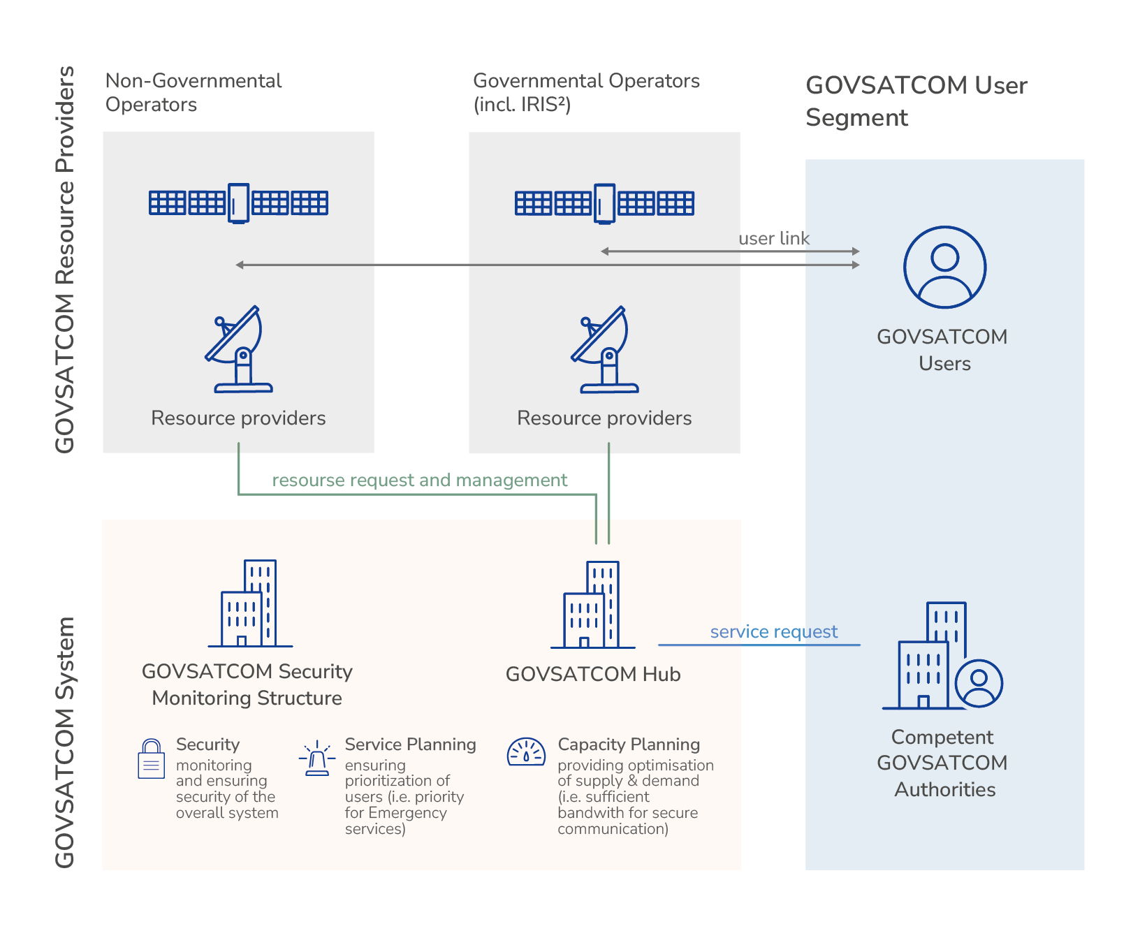
GOVSATCOM is a key part of the EU’s ambitious Secure Communications Program, also known as Infrastructure for Resilience, Interconnectivity and Security by Satellite (IRIS²). The main goal of the program is to ensure a reliable and controlled level of communications for all government bodies, European institutions, military, and crisis missions. Through GOVSATCOM, the European Union aims to reduce its dependence on commercial or foreign providers for its most sensitive communication needs.
Source: euspa.europa.eu
European Commission spokesperson Thomas Renier publicly emphasized that the key motivation is a recognition of the critical link between space technologies and defense. Unlike the three initiatives described above, Ukraine’s involvement in GOVSATCOM is not positioned as a purely civilian stage of integration into European space, but is explicitly viewed as a reliable tool for strengthening the country’s military resilience.
The main unique feature of GOVSATCOM is that it operates on a pooling and sharing principle. Instead of building a single monolithic constellation, it combines existing satellite capacities, both government-owned satellites from EU member states and certified commercial capabilities from private European operators. This ensures flexibility, redundancy, and geographically extensive coverage. The operation and coordination of these combined services is managed by EUSPA, which ensures interaction between military, governmental, and civilian users.
For Ukraine, where the full-scale war continues, participation in GOVSATCOM will be an important step in strengthening resilience. The program provides critically important secure communications designed to withstand modern threats of electronic warfare (EW) and active jamming. Access to interference-resistant channels should ensure reliable communication between key government and military structures, which is vital given the intensive EW attacks employed by Russia against Ukrainian telecommunications systems.
An additional benefit is the high level of security and encryption. GOVSATCOM uses certified European cryptographic solutions, a necessary condition for exchanging sensitive and confidential information. This not only protects data from interception but also significantly increases the level of trust between Ukraine, EU institutions, and NATO military missions and structures, facilitating joint planning and intelligence sharing.
Furthermore, GOVSATCOM serves as a reliable backup communication channel. In conditions of ongoing shelling and cyberattacks that destroy ground infrastructure, it guarantees continuity of command. In the event of national communication assets being taken offline, Ukraine will be able to instantly access the pooled capacities of GOVSATCOM to maintain vital government and emergency functions, ensuring resilience in crisis situations.
Although the full integration of Ukraine into GOVSATCOM is still under consideration, it is already clear that the decision to connect the country to the system did not arise spontaneously but is the result of a deliberate EU strategy to assist Ukraine. Today’s trend of strengthening ties between Ukraine and Europe in the domain of space clearly demonstrates the EU’s commitment to recognizing Ukrainian security as an integral part of European security. Advanced space programs promise to become a direct means of ensuring that security.